Bromsgrove Local Plan
Local planning authorities are required by the Government to update their Local Plans every five years. The current development plan for Bromsgrove District was adopted in 2017 and has now fallen significantly out of date. Bromsgrove District Council has acknowledged it needs to prepare a new local plan, the preparation of which is under way.
The site of the proposed development is being promoted for development through the emerging new Local Plan as a sustainable opportunity to contribute to housing requirements in the district. Bromsgrove District Council is currently at the scoping stage of the new local plan which is now being produced under the Government’s new plan making process, the details of which were published in the spring of 2026. The plan will be informed by the information that was gathered by the Council to support previous stages of plan making under the old system, including the Draft Development Strategy which was consulted on between June and October 2025. This document identified the site as a potential option for housing growth in Hagley (HAG02).
Increased housing targets for Bromsgrove District
In December 2024, the Government published a new National Planning Policy Framework (NPPF) which introduced a new method to calculate housing requirement figures. This method has been carried forward from the 2024 NPPF to the new NPPF (published 17th August 2026). As a result of needing to apply this method, the number of homes Bromsgrove District will need to deliver across the council area has increased significantly, from 386 to 713 homes per year.
Green Belt
The site lies within the Birmingham Green Belt. Bromsgrove District Council has recognised for many years the need to release land from the Green Belt in order to meet its future housing needs.
Taylor Wimpey considers that the site constitutes Grey Belt land under the criteria set out in the NPPF and having regard to the findings of Bromsgrove District Council’s Part 1 and 2 Green Belt Studies. The NPPF requires Local Planning Authorities to consider previously developed land first before moving onto grey belt sites and then finally Green Belt sites which are in sustainable locations. The development of grey belt land may not be considered to be “inappropriate” development within the Green Belt if certain criteria, as set out in the NPPF, are met.
Five-year housing land supply
The NPPF also requires that local authorities are able to demonstrate a five-year housing land supply. This is the amount of land that the Council must identify to ensure there are sufficient deliverable sites for residential development over the next five years. Bromsgrove District Council currently cannot demonstrate a five-year supply of deliverable housing land. In light of this, an outline planning application alongside the ongoing Local Plan process will help to contribute to meeting this shortfall at an early stage in the plan process, bolstering the council’s five-year housing land supply position.
Local Plans are the key documents through which local planning authorities set out a vision and framework for the future development of the area, engaging with their communities in doing so. Local Plans address needs and opportunities in relation to housing, the local economy, community facilities and infrastructure. The Local Plan provides a degree of certainty for communities, businesses and investors, and a framework for guiding decisions on individual planning applications.
Local planning authorities, such as Bromsgrove District Council, have a statutory responsibility to maintain an up-to-date Local Plan, and national policy indicates that Local Plans should be regularly reviewed, with the expectation this is done at least every five years.
The December 2024 NPPF significantly increased Bromsgrove’s housing targets from 386 to 713 homes per year and introduced the principle of grey belt development. These targets have been carried over in the latest version of the NPPF published in August 2026.
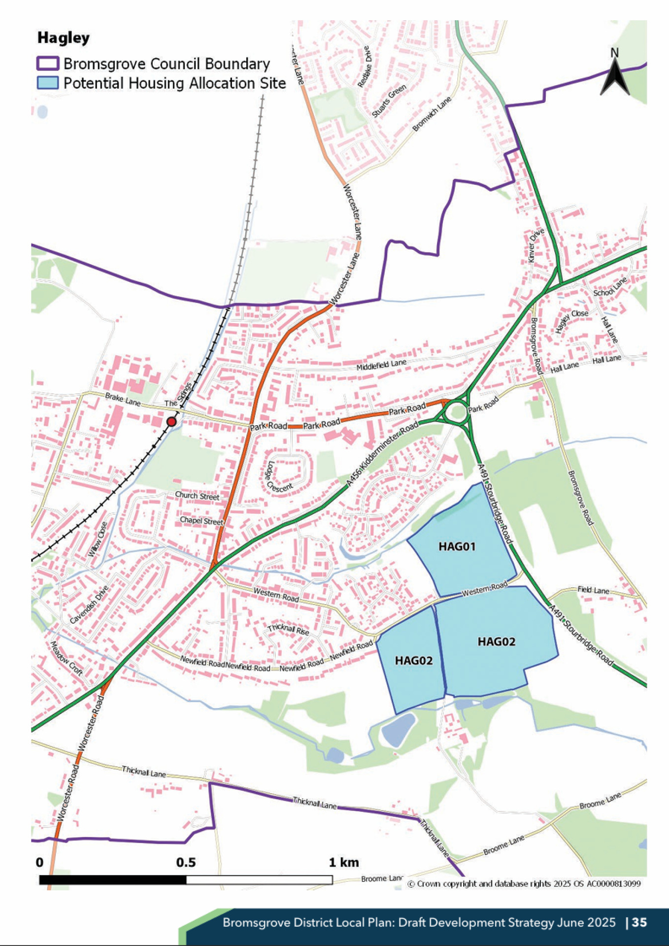
An extract from Bromsgrove District Council’s Draft Development Strategy (2025) showing the site as a potential housing allocation site (HAG02) – Click to enlarge